

Auzie Blevins permalink
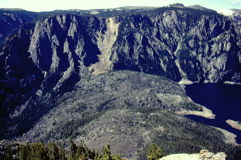
Here's a view of the Deep Lake Slide looking south across the highest point of the slide toward the opposite wall of the valley. Deep Lake is visible at right. Click on the arrow at top right for more photos.
Auzie Blevins permalink
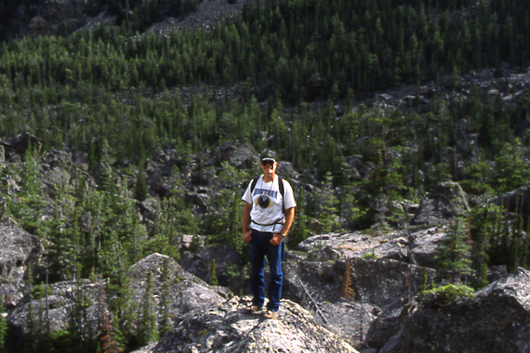
John Boehmke stands atop a large block of stone on a hike up to Deep Lake Slide. Some of the big rocks were difficult, even dangerous, to negotiate.
permalink
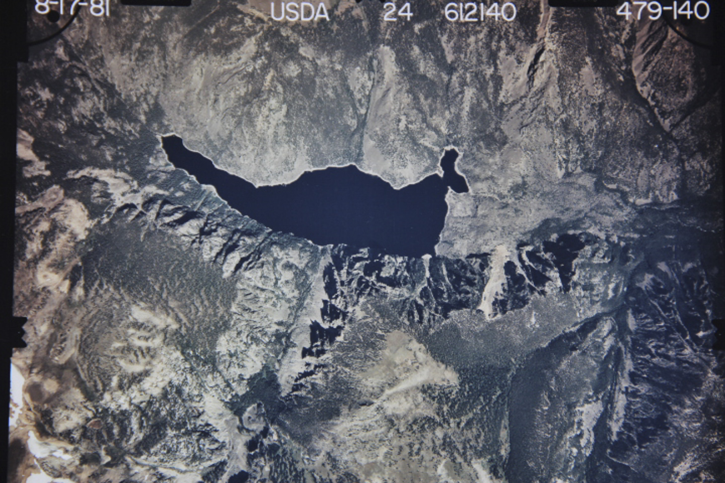
An aerial view of Deep Lake. The rock slide is in the upper righthand corner, the northeast corner, of the lake.
It doesn’t have quite the immediate appeal of Old Faithful, but there is a notable geological feature in the Beartooth Mountains that Auzie Blevins and John Boehmke believe more people should know about.
The feature is an immense heap of rock, the result of a gigantic rockslide that formed a natural dam and created Deep Lake, one of the largest bodies of water in the Beartooths.
Deep Lake is remote, but it is hardly unknown and it’s no secret that it was formed by a rockslide. Apparently, however, no one before Blevins—in consultation with Paul Burley, a geologist and civil engineer—attempted to estimate the total volume of the Deep Lake Rockslide.
According to their calculations, the slide is 1,100 feet deep at its apex and contains nearly 500 million cubic yards, or about 1 billion tons, of material. By comparison, the Hebgen Lake Slide along the Madison River, which was triggered by an earthquake in 1959 and created Quake Lake, is estimated at just 43 million cubic yards. The Gros Ventre Slide, 30 miles east of Jackson, Wyo., is estimated at 50 million cubic yards.
“It does show that it’s huge,” Blevins said of their research into the Deep Lake Slide. “It’s just mind-blowing. We concluded that it’s probably the biggest in North America.”
The second-largest slide in North America, Blevins said, is the Hope Slide in British Columbia. It comes in at 61.5 million cubic yards.

Years ago, Blevins and Boehmke tried to have the slide considered for listing as a national natural monument, only to learn that such landmarks could be established only on Department of the Interior lands, not on Forest Service Land.
So, early in 2012, they submitted a formal proposal to the Shoshone National Forest, which has jurisdiction over Deep Lake, asking to have the slide designated an Area of Special Interest in the forest’s management plan, which was then in the process of being revised.
The revised plan was formally adopted last spring, and the Deep Lake Slide didn’t make the cut. The plan said landslides similar to the one at Deep Lake are already “well represented and interpreted in the Greater Yellowstone Area,” pointing to the Quake Lake Earthquake interpretive Center and the Gros Ventre Slide Geological Area.

Ed Kemmick/Last Best News
Auzie Blevins, at the computer in his home near Briarwood, looks at photos of Deep Lake Slide.
Olga Troxel, acting planner for the Shoshone National Forest, said the “special interest” designation wouldn’t have meant much for the slide area anyway. Sometimes special-interest areas are established to protect, say, a rare plant, and giving it that designation might obligate the Forest Service to suppress fires in that area, she said.
But for something like the Deep Lake slide, which is so remote, reachable only on foot and made up of rocks, “for the most part, you really can’t hurt those areas,” she said. One thing such a designation could do, she said, is bring it to the attention of people who might want to do further research on the area.
That, in fact, was one of the main reasons Blevins and Boehmke asked for the designation. In their proposal, they listed several possible research topics and raised numerous questions about the slide, and about Deep Lake and its environs.
For starters, they said, the accuracy of their volume calculations could be tested by determining just how deep Deep Lake really is. The original valley bottom probably remains undisturbed just upstream of the slide material, they said, so using a depth finder to get some cross sections of the submerged valley could improve their calculations of the depth and volume of the slide material.
Also, Blevins said, “the Deep Lake slide cries out for someone to do some cosmogenic testing,” a technique commonly used to date geologic events like lava flows, rockslides and meteorite impacts.
It was Boehmke who first got interested in the slide. He doesn’t even remember how it came to his attention, but he likes to collect and study detailed maps and assumes that was how he learned of the Deep Lake Slide.
Boehmke, who has degrees in mechanical engineering, biology and zoology, became friends with Blevins, who has a degree in geography, when they were both working for the Bureau of Reclamation in Billings on resource and environmental issues. They hiked into the lake for the first time in 1992.

John Boehmke
When Blevins, seen above, and John Boehmke, hiked up to Deep Lake Slide for the first time more than 20 years ago, they ran into gigantic blocks of stone that had been transported by the slide.
They went up from the east side, following Littlerock Creek. It is a long, rough route, and they didn’t even make it to the top of the slide on that first attempt. Beohmke said they should have gone up the slope, rather than staying on the face of the slide. Toward the end of their hike they were stuck in an area littered with huge boulders, which is typical of big rockslides.
Even so, “after we saw it and how big it was and everything, we sat down and started figuring out some volumes, just off the tops of our heads,” Boehmke. After that, he said, it became more Blevins’ obsession than his, and it was Blevins who later recruited Burley, the geologist, to help him with the volume calculations.
Boehmke and Blevins have both been back multiple times since that first trip. Two routes from the Beartooth Highway, which involve hiking down to Deep Lake rather than up, are much easier than the one from the bottom. One route follows the Morrison Jeep Trail and involves a four-mile hike, while the other involves a 5½-mile hike across the open plateau from the Beartooth Highway.
The hike from below has been even more difficult since a fire in the early 2000s. In the years after the fire, thousands of dead trees have fallen over or were blown over, making the route almost impassable.
Blevins has spoken with forest managers about the possibility of clearing a trail from down below, to make it more accessible to sightseers and future researchers. As part of their work on having the area recognized, Blevins and Boehmke have taken some Forest Service employees up to the slide.
Last summer, Blevins hiked to the slide with Dan Siefert, a geologist with the Custer National Forest. The Shoshone doesn’t have its own geologist, but Blevins wanted somebody with a geology background and Forest Service credentials to have a firsthand look at the area. Siefert, who had never been to Deep Lake before, was suitably impressed.
“From the standpoint of a geologist, it’s definitely a unique feature,” he said. “It’s a very impressive rockslide.”
He didn’t do anything other than read Blevins and Boehmke’s proposal and hike down to the slide, Siefert said, but “just looking at their proposal, it seems legit. … It’s definitely a cool geologic feature.”
Maybe all that’s needed is for Forest Service maps and other printed materials to mention and briefly describe the Deep Lake rockslide, Siefert said, so that other people will come to appreciate a feature that might otherwise be overlooked.
