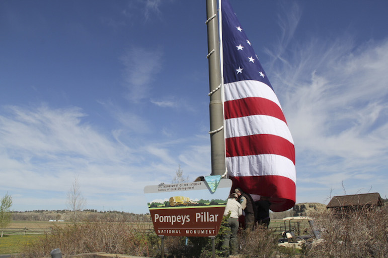
BLM workers struggle to hoist a 40-by-25-foot flag at the entrance to Pompeys Pillar National Monument on Wednesday, in preparation for the opening day of the summer season Saturday. Click on the arrow at top right for more photos.
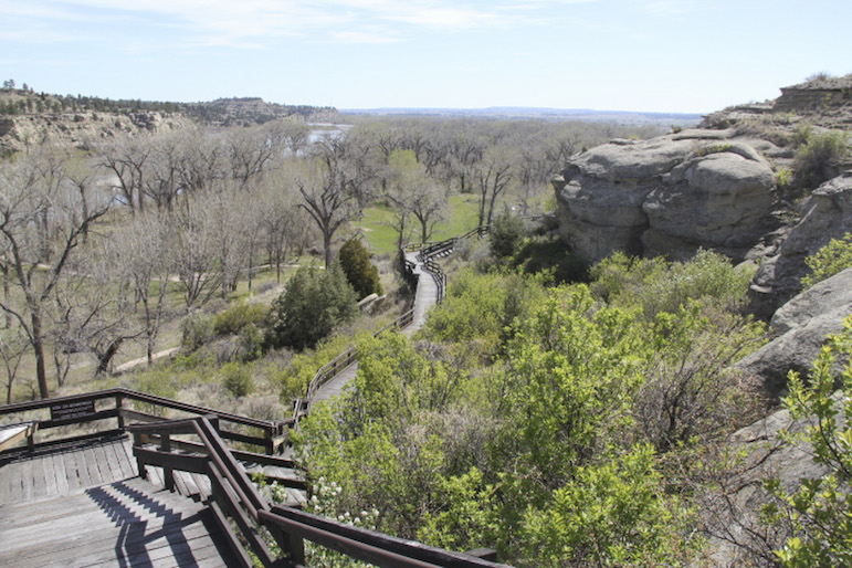
A view of the boardwalk from near the top of the monument.
Except for a few Bureau of Land Management employees, Brigit and Ken Painter and their two dogs had Pompeys Pillar National Monument pretty much to themselves Thursday morning.
Brigit Painter said they live in Huntley and go out to the monument every day to walk their dogs.
“We just love it here,” she said. “We’re kind of not looking forward to the opening.”
Jeff Kitchens is. He manages the monument for the BLM, and he’s excited about the official opening of the site and its interpretive center on Saturday. And this year, in hopes of encouraging more public involvement in the 51-acre monument, he’s sponsoring a community cleanup day for the site.
Volunteers, who will be let in free Saturday, can help with gardening, landscaping, trail work, fencing and other chores.
The monument, 25 miles east of Billings, will be open every day from 9 a.m. to 6 p.m. until the last weekend in September. There is a charge to drive in to the interpretive center parking lot, but you can park outside the gate and walk in for free 365 days a year. It’s about a mile from the gate to Pompeys Pillar.
About that name
Pompeys Pillar was known to Crow Indians as Iishbiiammaache, variously translated as “Where the Mountain Lion Preys,” “Where the Mountain Lion Died” and “The Mountain Lion’s Lodge.”
In his journal, William Clark named the formation “Pomp’s Tower.” Pomp or Pompy was the nickname of Jean Baptiste Charbonneau, the son of the expedition’s Shoshone interpreter, Sacagawea.
When the Lewis and Clark journals were first published in 1814, editor Nicholas Biddle changed the named to “Pompey’s Pillar,” evidently assuming Clark had named it after a classical monument in Egypt that honored the Roman general Pompey the Great.
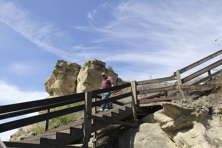
The pillar’s claim to fame is that William Clark of the Lewis and Clark Expedition carved his name on the sandstone butte on July 25, 1806. Although the famous inscription has been deepened on several occasions, perhaps even completely reworked, it remains the centerpiece of the monument.
But the site has always been celebrated for broader reasons, especially since the interpretive center was opened in 2006, during the Lewis and Clark bicentennial.
Kitchens calls it “the ultimate example of a cultural crossroads.” From the top of the monument, accessible by a wooden boardwalk, there is, as Clark wrote in his journal, “a most extensive view in every direction.”
The pillar was once a stone peninsula, part of the north shore of the Yellowstone River. The river ate through the neck of the peninsula ages ago, leaving it an island in the Yellowstone. Eventually the river shifted still more and the pillar stood by itself on the south bank.
The resulting gap made for the only break in the Rimrocks for miles in either direction. Also, a gravel bar at the mouth of Pompeys Pillar Creek created a relatively shallow river crossing, turning the site into a prime river crossing for animals and later for human inhabitants of the area.
Clark mentions in his journal seeing “emence herds of Buffalow, Elk and wolves” from the top of the pillar. Clark, whose observations were as keen as his spelling was creative, referred to the sandstone monument as “a remarkable rock.”
Before and after Clark’s time, it was a popular spot on which to leave one’s mark. The first European to make a written reference to the rock was French trader Francois-Antoine Larocque, who was with a party of Crow Indians when he stopped there about a year before Clark’s visit.
He wrote of seeing an Indian pictograph showing “a battle between three other people on horseback and three others on foot.” A study commissioned by the BLM in 2001 documented some 2,000 separate names, dates, initials, graffiti and pictographs on the monument.
“A steady stream of trappers, surveyors, soldiers, settlers, ranchers, farmers, and even picnickers engraved their names on Pompeys Pillar,” the report said. “They left no accessible section of the butte untouched.”
Ed Kemmick/Last Best News
Pompeys Pillar rises majestically from the river bottom.
The report said one cowboy, in 1915, even managed to carve his name on a seemingly inaccessible cliff face by having his companions lower him down to the spot with ropes tied to his saddle.
From the top of the monument, Kitchens said, you can also see, in effect, the history of the West, starting with the river itself, an important transportation corridor, and expanding out to old wagon trails, the railroad and the interstate highway. There are also vestiges of early homesteads and the Huntley Project’s system of irrigation canals.
“You have just this chronicle of all the people that have come through,” Kitchens said. “I don’t know that I’ve been to another place in our country where you can say that.”
Ed Kemmick/Last Best News
A marmot makes an appearance alongside the boardwalk leading to the top of the monument.
The crossroads continues to attract lots of people. Kitchens said about 35,000 people entered the site during the summer season last year, and another 500 to 1,000 a month visited in the off-season.
He said visitors generally fall into one of four categories. The first are residents of the surrounding area, including Billings, who bring out-of-town friends or relatives to the site. The second are more or less accidental visitors who see the signs as they are driving by and decide to check it out.
Then there are people specifically on the Lewis and Clark trail, perhaps visiting sites along one segment of the trail from St. Louis to the West Coast every summer. In the final category are serious Lewis and Clark buffs from all over the world who want to stand in the one spot where one of the famous explorers is definitely known to have stood.
The monument was privately owned for many years, most recently by the Foote family, and in 1965 it was designated a National Historic Monument. It was acquired by the BLM in 1991 and reopened to the public in May 1992.
In addition to the pillar itself, the extensive grounds have paved and unpaved trails dotted with interpretive kiosks, and in the interpretive center there are numerous displays, including interactive displays, and a gift shop.
“If you take the time to do all of it, it’s easily a two-hour venture,” Kitchens said.
Ed Kemmick/Last Best News
Here, from the top of the monument, is an example of “a most extensive view in every direction” mentioned by William Clark.
Clark Days this year will be on July 25 and 26. It will include presentations, interpretive programs, demonstrations and nature walks, and Saturday, July 25, will be the only night of the year on which overnight camping is allowed.
The BLM gets a lot of help from the Friends of Pompeys Pillar, which coordinates the activities of volunteers who work in the Interpretive Center, lead tours, serve as greeters, do landscaping and work in other positions around the site. Kitchens said 220 volunteers put in 6,300 hours during the 2014 season.
Kitchens hopes that having the volunteer cleanup day on Saturday’s opening will encourage more people to get involved.
“Any chance that you have where the community can feel actively engaged in a part of something, they tend to have more of a stake in it,” he said. “I mean, having a national monument in your backyard in Billings is kind of cool.”
Details: There is a new fee structure this year for Pompeys Pillar National Monument. An annual pass is $20. A daily pass for noncommercial visitors is $7 for groups of six or fewer people, $12 for groups of 7-24 and $20 for groups of more than 25 people.
You can drive to the monument from Billings on Interstate 94 or take the more interesting Highway 312.